BLAEU, Joan / HONDIUS, Henricus
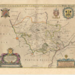
Ditio casletana in comitatu flandriae vulgo Cassel Ambacht
Amsterdam, Henrici Hondy, 1644 [1659-72]
- Dimensions: 45 x 54 cm
- Condition: Légères rousseurs marginales
- Couleur: Coloris Original
- Technique: Gravure sur cuivre
- Description de l'état: Très bon
Référence: 677-4
88,00 €
Disponibilité : 1 in stock
poser une questionDescription
Très belle carte du domaine de Cassel dans le comté de Flandre, communément appelé Cassel Ambacht par Vedastus du Plovich, Antoine Sanders (1586-1664) et publié par Henricus Hondius (1597-1651).
La carte est centrée sur le domaine de Cassel dont les frontières sont tracées avec un contour coloré de l’époque. Elle est finement décorée de deux grands cartouches et des armoiries de la Flandre.
Cette carte est apparue pour la première fois dans Flandria Illustrata, vol. II, de Sanderus (Klön : Cornelis van Egmondt c.s = Amsterdam Joan Blaeu, 1644). Cet exemplaire est publié en 1663 dans le quatrième volume de l’édition espagnole Atlas Nuevo, imprimée en 1659-72.
Référence : Van der Krogt, 2, 3290:2
Produits connexes
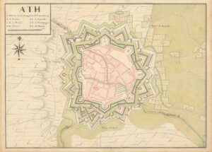
[Anonyme]
[Plan Manuscrit] – Ath
1 500,00 € Add to cartRéférence: 662-2
Superbe plan original manuscrit de la ville d'Ath.
1 500,00 €DE FER, Nicolas
La Hollande ou Les Provinces unies des Pays-Bas où sont le duché de Gueldres, les C[om]tez de Hollande Zelande et Zutphen
245,00 € Add to cartRéférence: 496-66
Carte des Provinces unies des Pays-Bas
245,00 €[Anonyme]
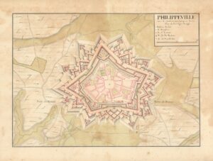
[Plan Manuscrit] – Philippeville avec ses sous terrains marquez sur le plan de fine ligne rouge
950,00 € Add to cartRéférence: 662-4
Superbe plan original manuscrit de la ville de Philippeville.
950,00 €[Anonyme]
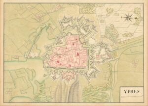
[Plan Manuscrit] – Ypres
1 500,00 € Add to cartRéférence: 662-13
Superbe plan original manuscrit de la ville d'Ypres.
1 500,00 €
![La Hollande ou Les Provinces unies des Pays-Bas où sont le duché de Gueldres, les C[om]tez de Hollande Zelande et Zutphen](https://pingelrarebooks.com/wp-content/uploads/2022/11/10940-La-Hollande-ou-Les-Provinces-unies-des-Pays-Bas-ou-sont-le-duche-de-Gueldres-les-Comtez-de-Hollande-Zelande-et-Zutphen-scaled-300x235.jpg)