![Gouvernement général des provinces du Lyonnois Forez et Béaujolois qui comprend la généralité de Lyon [...]](https://pingelrarebooks.com/wp-content/uploads/2022/05/11112-Gouvernement-general-des-provinces-du-Lyonnois-Forez-et-Beaujolois-qui-comprend-la-generalite-de-Lyon-scaled-150x150.jpg)
JOUBERT, Louis Martin Roch / BERLIE, l'Abbé
Gouvernement général des provinces du Lyonnois Forez et Béaujolois qui comprend la généralité de Lyon [...]
Lyon, Veuve Daudet et Joubert, 1767
- Dimensions: 71 x 54.5 cm
- Technique: Gravure sur cuivre
Référence: 535-17
180,00 €
Disponibilité : 1 in stock
poser une questionDescription
La carte est orientée ouest et comprend les régions de Velay, d’Auvergne et de Dauphiné. Elle comporte un tableau avec le positionnement des villes principales sur la carte et une note qui donne les distances entre elles. Sur la carte, Lyon est représenté avec son mur d’enceinte et avec une typographie différente afin de la mettre en valeur.
Cette carte fut dressée d’après les opérations de messieurs de l’Académie Royale de Sciences en 1767.
Produits connexes
[DUBRENA, V.]
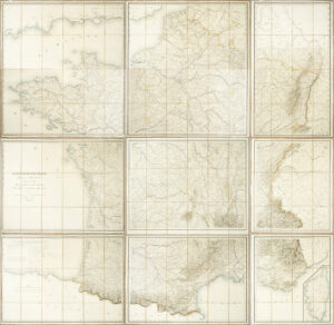
Carte hydrographique de la France présentant l’ensemble des voies navigables et des chemins de fer.
2 000,00 € Add to cartRéférence: 335-2
Belle carte de France en coloris original, offrant une représentation détaillée des côtes, fleuves, canaux, rivières et chemins de fer.
2 000,00 €WIDT, Frederick de
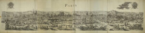
Vue de Paris
28 000,00 € Add to cartRéférence: 073
Spectaculaire vue de Paris en quatre feuilles.
28 000,00 €NOLIN, Jean-Baptiste
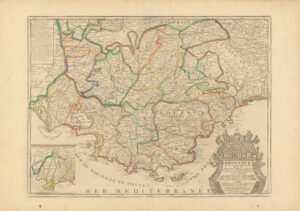
Le Comté et gouvernement de Provence avec les terres adjacentes
225,00 € Add to cartRéférence: 514-8
Carte de la Provence, depuis le sud du Dauphiné jusqu’à la mer Méditerranée.
225,00 €