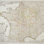
Très élégante carte de France de Delisle au contours coloriés à l’époque.La carte s’étend de l’Atlantique aux Alpes et du Sud de l’Angleterre à l’Espagne. Elle présente un élégant cartouche de titre aux armes du roi de France à qui la carte est dédiée. Petit manque de papier dans l’angle inférieur gauche, une petite tache.
DELISLE, Guillaume / BUACHE, Philippe
Guillaume Delisle (de l’Isle) (1675-1726), est l’une des plus grandes figures de la cartographie française. Fils aîné et élève de l’historien et géographe Claude Delisle, il entre à l’Académie des sciences en 1702 pour étudier avec l’astronome Jean-Dominique Cassini. Il enseigne la géographie au jeune Louis XV et est le premier à recevoir le titre de Premier Géographe du Roi en 1718. Delisle est considéré comme étant à l’origine de la cartographie moderne. L’une des principales contributions de Delisle a été de faire la transition entre les cartes décoratives de l’école hollandaise et une approche plus scientifique. Il a supprimé les éléments ornementaux et a fondé sa cartographie sur toutes les informations disponibles. Tout au long de sa vie, il a constamment mis à jour sa collection de plus de 100 cartes pour refléter les nouvelles découvertes. Ainsi, ses cartes donnent un aperçu précis de l’état des connaissances géographiques de l’époque. Celle de Delisle fut la première à corriger les longitudes de l’Amérique, à écarter l’erreur bien établie de la Californie comme île, à délimiter correctement la vallée du Mississippi et à introduire de nombreux nouveaux noms de lieux. Martin & Martin, Maps of Texas, pl. 19, p. 98-9 ; Schwartz/ Ehrenberg, p. 140-41, (illus.) 146 ; Cumming, Southeast, n° 170 ; Kohl,Lowery Collection, p. 230.
Philippe Buache (1700-1773) était un élève de Guillaume Delisle et un géographe français renommé. Après la mort de Delisle en 1726, il s’associa avec la veuve et épousa sa fille en 1729. La même année, il est nommé Premier Géographe du Roi et il est élu membre de l’Académie des Sciences l’année suivante. Philippe Buache forme un contraste complet avec son prédécesseur. Il est l’un des principaux protagonistes de la géographie théorique et, en collaboration avec Joseph Nicolas De l’Isle, il produit certaines des cartes de l’Amérique occidentale les plus fantastiques et les plus imprécises jamais imprimées. Néanmoins, Buache a apporté une certaine contribution au progrès de la cartographie. Il fut l’un des pionniers de la géographie physique divisant à la fois la terre et l’eau en chaînes de montagnes et en bassins. Il fut le premier à suggérer que l’Amérique et l’Asie avaient été autrefois réunies au niveau du détroit de Béring, et l’un des premiers à tirer profit de la technique des courbes de niveau ou des isobathes dans sa carte de la Manche en 1737.
Tooley – The mapping of America 43 ; Martin & Martin, Maps of Texas, pl. 19, pp. 98-9 ; Schwartz/ Ehrenberg, pp. 140; Kohl,Lowery Collection, p. 230 ; Cumming, Southeast, no. 170


![[FRANCE & BELGIQUE] Tercia Europe Tabula](https://pingelrarebooks.com/wp-content/uploads/2022/09/10626-FRANCE-BELGIQUE-Tercia-Europe-Tabula-scaled-300x220.jpg)